-
 New walking and running trail could come to Vinton dubbed "Little Nevada" because of the shape.
Matt Boggess, director of the Vinton Parks and Recreation Department, presented a possible trail master plan for Vinton.
The discussion concerning building a walking/running trail through Vinton began almost 10 years ago. The original plan had put a trail near the hospital.
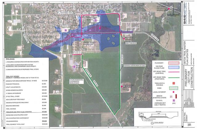
The new plan created with the help of Shive-Hattery Architecture and Engineering would move the trail area to the southern sections of town.
Boggess said of the trail plan that it would still meet the needs of Vinton,
The original plan had the city setting aside $250,000 toward the project and the current project would run around $650,000 to complete.
Boggess explained to the council that in addition to the city funds, there is also grant money available as well as a possible trust through which financing could become available. There could also be funds available through the CAT program (Community Area Tourism) and possibly asking the freshman legislator State Representative Gerhold to lend a hand to lobby for grant money, and other sources for grants.
The idea is to build a trail that would help kids move between the school safely, as well as connecting the new addition in the southern part of town near the high school.
The plans presented to the council by Justin Campbell, the lead engineer, is a draft of ideas as well as updating the costs from 10 years ago. The updated costs can be seen on Sheets 1R and 2R alongside the proposed maps of the trail.
There was a discussion about the width of the trail. The idea is to stick as close as we can to a 6-foot width avoiding a 10-foot width. If the path extends to that 10-foot width, there would be more guidelines that the city would have to follow. After observing the traffic near the B.L. Anderson park, Boggess felt comfortable saying that a width of 6 foot would be plenty.
In addition to limiting the width of the project that narrower width would help to lengthen the trail.
It was suggested that Vinton Parks and Recreation Department would be responsible to maintain the project. The question was asked about what would happen when it gets old and falls into disrepair. The suggestion was made that when it gets old, VPRD might consider making it into bike trail at that point.
The question was asked about the trail possibly going through a resident's land and the Mayor suggested that the city would probably take care of the initial expense but share maintenance if that should happen. Right now that wouldn't be an issue because the project doesn't affect any of the residents. It might, however, affect the Vinton Family Restaurant's sidewalk.
Priority is the south loop or "Little Nevada" as it was dubbed because of its shape, connects the new development and helps with the connectivity to all the schools giving Vinton "the biggest bang for our buck" according to Boggess. A section on map 1-R shows the trail converging on the backside of the football field, which is already elevated and there is thought that the school might be interested in investing some money toward the project there.
Changing and editing the plans from 10 years ago increases accessibility, increases a safe way for children to get to school, and increases the likelihood of working with healthy hometown initiatives by Wellmark and other which could provide more funding from grants.
There was talk of the "trail to nowhere" (the sidewalk that runs to the east of Tilford) and utilizing the walkway that is already there, as part of the project would also extend the project without added cost. Existing sidewalks might have to be repaired to bring them up to code for the project, but it would be up to the city to decide who would be responsible for covering that cost.
When completed the project would be about 3.1 miles or 5K. Depending on several variables, the plan is to start on this project toward the end of 2019 and into 2020.
Boggess explained that he was simply updating the council on the new information and that there was no formal action needed at this time.
Council member Nathan Hesson, agreed that "it would definitely be used."

Comments
Submit a CommentPlease refresh the page to leave Comment.
Still seeing this message? Press Ctrl + F5 to do a "Hard Refresh".